| Bishop's Cleeve, a brief history |
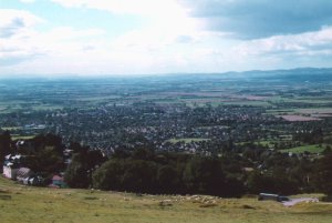
IntroductionWhat follows is a brief summary of the early history of Bishop's Cleeve. The information detailed was gleaned entirely from the two books referenced below. I am personally no expert in this subject. My intention was to eventually add more pictures of the village to supplement this text and to include more details of the recent history. However, there is already an excellent site dedicated to providing a pictorial archive of the village. You can get to this site by following this link. Other Bishop's Cleeve related links are give below.
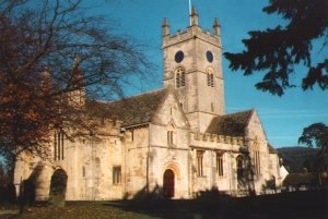
Bishop's Cleeve appears to have originated in the late 8th century when Aldred, sub-king of Hwicce, gave land to support a Minster church in the area dedicated to St Michael the Archangel. A century later and the land came into the hand of the Bishops of Worcester where it remained until the sixteenth century. The area was known as the Bishop of Worcester's manor of Cleeve, from where the modern name probably originates. By the time of the Domesday Book of 1086, the estate measured 30 hides. A hide was traditionally the unit of land, which could support a family, but was also used as a unit for taxation. The Domesday Book entry reads: "There are 30 hides, 3 ploughs an demesne, 16 villagers and 19 smallholders with 16 ploughs. There are 8 slaves and 1 horse. A priest has 1 hide and 2 ploughs. A radknight with 1 hide and 2 ploughs. There is a very small wood" By the late thirteenth century, the estate contained 11 free tenants who held land. They paid rent and provided other services to the Bishop. Slowly over the following centuries, the tenants acquired more independence from the church. However, it was not until the sixteenth century and the dissolution of church institutions that the land became the property of the King, who subsequently sold it to local manor lords. References
Cleeve Common and the North Coltswolds, by John V. Garrett (ISBN 0-946328-46-3)
|
| Links |
|
Images of Bishop's Cleeve - a historical archive. A very informative site about Cleeve Common. The Tithe Barn - Bishop's Cleeve Village Hall. Wikipedia Entry for Bishop's Cleeve. |
| Where Next |
|
| [Home] [BSG] [Wow Cakes] |